Here’s the Timing on Today’s Strong Storms in Louisiana
Just after midnight this morning the Lake Charles National Weather Service Radar scan was only picking up a few light sprinkles in the Gulf of Mexico. Just four short hours later a peak at the radar screen will show that Mother Nature has in fact turned on the faucets and the rain is coming this way. Here's the radar scan from 3:30 this morning.
Now, if you click this link, you can see just how much further rain and storms have progressed since the wee small hours of this Thursday. You've probably figured out that all the rain in the Gulf of Mexico is going to be moving into and over Louisiana and the Gulf South later today.
When Will the Heaviest Rain Fall in Louisiana Today?
Based on recent weather model runs I think it is a pretty safe bet to suggest that most of southwestern Louisiana will see at least a shower or a sprinkle by lunchtime or just after. Here is how the National Weather Service Forecast Office in Lake Charles breaks down the timing for today's strong to severe storms.
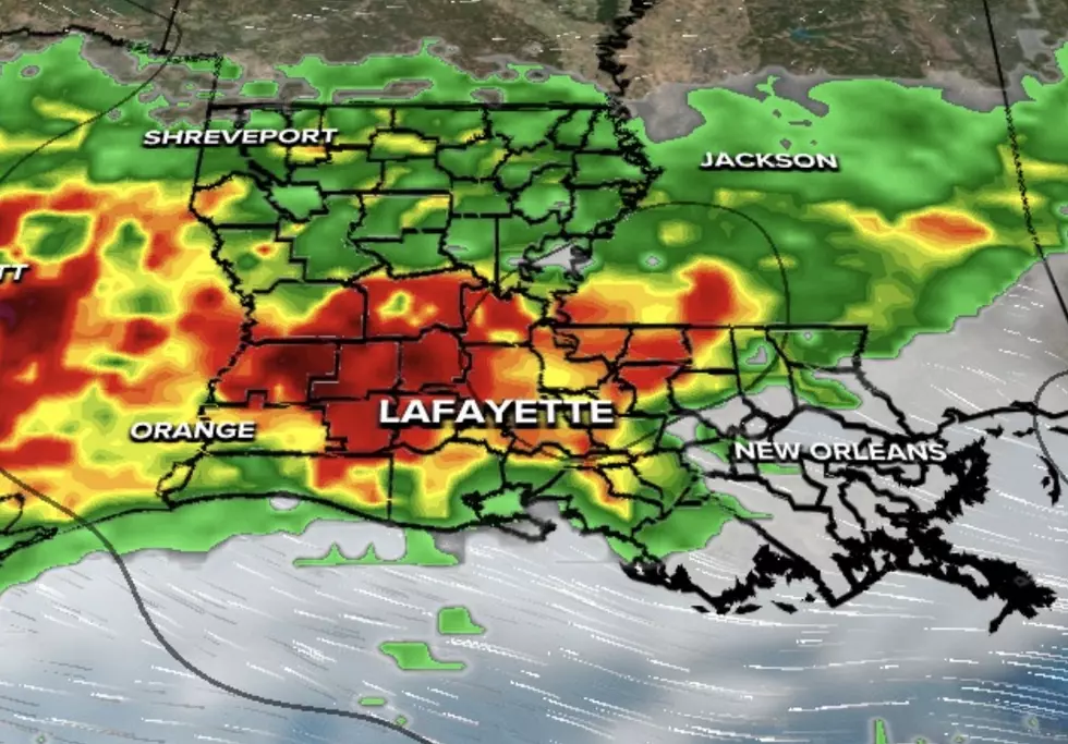
The heavier showers won't move into the area until carpool pick-up time or drive-home time later today. Here's what the GRAF Model run was suggesting for the area about 5 p.m. today.
KATC TV 3 Chief Meteorologist Rob Perillo mentioned something additional about the heavy rainfall potential in his blog post on the TV station website. Rob mentioned the potential for some of the thunderstorms that develop over the area to start "training".
"Training" is when showers and storms move over the same area, almost traveling in a straight line such as a train track would do. When that happens the same parts of the area are inundated with heavy rain as different storms move over the same geographical location time and time again.
Look at some of the rainfall totals the GRAF Model was suggesting.
Yeah, that's an 11.25" by Lafayette, a 9.50" at Gueydan, and over a foot of rain at Cypremort Point. Now would be the time when we remind you that this is only one model solution and not an official forecast. In fact, this scenario does seem a bit unlikely but it does show how the computers were locking in on the "training" potential for some of the heavier storms.
We should also make you aware that in addition to a significant rainfall event much of South Louisiana could experience strong to severe storms today too. Some of those storms will likely contain frequent lightning, heavy rain, and gusty winds, and there is the possibility of some tornadoes later today as well.
In addition to the heavy rain/severe weather threat, there is also a wind advisory posted for much of the area today as well. Gusty winds will be picking up from the southwest later today and it should be quite blustery at least through early Friday morning.
Rain chances will decrease during the day on Friday but ramp back up again on Friday night and stay fairly high for Saturday morning. The threat of showers will decrease a bit for Saturday afternoon and evening. With only a slight risk of rain in the forecast for Sunday.
10 Fads of the 2000s You’ve Probably Already Forgotten
Gallery Credit: Bruce Mikells


