Tropics: Dorian Weaker, Fernand Stronger, Gabrielle Forms
Can you tell we are almost at the peak of the Atlantic Hurricane Season? With three named storms in the Atlantic Basin already and two other tropical entities worth watching it's pretty easy to deduce isn't it?
Here's the latest on the storms most likely to affect you. Okay, not a direct effect but you know what we mean.
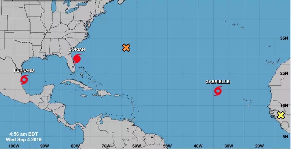
Tropical Storm Fernand- It was designated as a tropical storm yesterday morning. By this evening it will likely be a tropical depression slowly losing steam over the mountains of Mexico. As of the 4 am advisory from the Hurricane Center, Fernand had maximum sustained winds of 50 mph and was on a westward track that should mean landfall in northern Mexico late this evening or in the wee hours of Thursday.
Hurricane Dorian- It's the storm that just won't leave. It looks as if Dorian will be a bother for the Florida, Georgia, and Carolina coasts for a few more days. The good news about Dorian is that it is weaker. Maximum sustained winds with the storm are estimated to be 105 mph. The center of Dorian was located about 100 miles east of Daytona Beach Florida as of 4 am. Its forecast track should keep it hugging the coastline until sometime Thursday when it might make landfall in coastal South Carolina.
Tropical Storm Gabrielle - This system earned Tropical Storm designation early this morning. It's a minimal tropical storm at this time. Forecasters expect Gabrielle to stay out at sea and eventually become extra-tropical by later this weekend or early next week.
The other two "hot spots" in the tropics are an area of disturbed weather in the open waters of the Atlantic near Bermuda and a tropical wave that is rolling off the African continent. Those two entities will be monitored for further development over the next several days.
More From 99.9 KTDY